
I woke up feeling a little blah, did a couple hours of energy/spiritual work, and felt a lot better. I then redesigned the Reiki room, put away all the Xmas stuff from the living room and packed it down to storage, along with a half dozen other boxes from the closet in the spare room.
I walked our dog Rory down to the Village to pick up a parcel. Rory struggled along the way back, ice clinging to his poor paws, but I couldn't carry both him AND the big parcel. I got a LIFT up the hill. As the owner of a nearby dog rescue centre, he already knew our neighbor with the two dogs, and our dog sitter. Lol.
Unwrapping the big parcel, I discovered that it was our New Nespresso machine that had finally arrived! I sipped a freshly brewed decaf, and felt pretty accomplished.
Colin was working from home, and wanted to do a short lunch-time hike. We decided on Dorman Point "again," but this time, in the opposite direction, starting by heading UP the trail, then back down on the road. And THIS time, we'd go all the way up to the lookout. I guess if you put the two blog entries together, you'd get the complete trail in both directions. ;)

As I mentioned before, the Dorman Point trail was probably one of the best-known on Bowen Island, after Mt Gardner. A short but rewarding hike, it was about 2.5 km round trip from the ferry, and had an altitude gain of about 105 m up to the lookout. While it was a well-maintained trail, some sections were fairly steep. There was a sign with a map of this hike, along the boardwalk at Bowfest Beach. It posted the trail length and estimated a 1.5 hour return trip. Here's the relevant portion:

However, we didn't walk from the ferry, but from the Crippen Park entrance on Dorman Rd. The entrance was marked with a large green Parks sign, right before the first turn of Dorman Rd. There was a visitor parking lot set among the trees at the entrance of the park.


We walked through the parking lot, past the yellow post and covered picnic area, and into the Bowfest field. We didn't stop at the clean, well-appointed outhouses, which sat off to the right.

Crossing the field, the footprints of previous hikers were frozen deep into the snow. I was somehow light enough to not break the upper crust of snow, while Colin fell through with nearly every step.

At the beach, the tide was high, but the mountains were crisp against the sky, and the boats in the marina bobbed merrily. We could see Dorman Point stretching off to the right.

The trail signpost for the Dorman Point trail was quite close to the beach, on the right side.

We followed the trail up to the first junction, where we followed the next post's arrow to the left.


It wouldn't have made much difference if we had gone straight (ie taken the right hand fork), because that trail went up to a hydro box, then swooped left and rejoined the main trail (the left hand fork).
A few metres after the previous junction, there was another junction, and again we followed the post's arrow, this time to the right. The trail on the left would have led directly back to the beach, a little farther along the coastline than where we had entered.

Even though we were heading uphill, the snow on the trail suddenly vanished, and we had a nice dry walking surface... albeit one still covered in fallen branches from the recent wind storm.


Once we navigated that stretch, the path cleared up even more, although huge fallen trees along the trail were constant reminders of all the scary crashes I heard in here that day, while walking on Dorman Rd.


The trail started switch-backing up the side of the hill (this was notably absent on the Parks' map I saw at the bottom of the trail), and we passed a handrail that also served to block off a small side-trail. I had a vague memory of the trail's name: a woman's name... something like "Betty's Trail"... I also had a vague memory that I used to know where that trail led, years ago, but it was lost in the mists of my memory.


On some days, this section could be muddy, but in the frigid depths of winter, the water froze into ice crystals which crunched beneath our feet.

As the trail continued to zigzag uphill, the sunlight filtered through the trees. It took me back to one summer hike I did here years ago, when the sun's rays were like a lacy blanket, covering the whole area. I also remembered the many red huckleberries that grew wild along here in the summer. YUM!!!

At one point, bits of houses peeked through the trees, and I realized that the trail must have been approaching Robinson Rd. I remembered walking here in the summer years ago, and not being able to see houses. I didn't know if it was just because of the usual reduced foliage of winter, or whether big storms like the one Bowen had just had, had decimated the undergrowth.

At Robinson Rd, more trail posts directed us to take the trail on the left, that continued off the end of the road.


This was the last 200 m to the viewpoint, and it was STEEP. We didn't even attempt it on our last visit here, as it was covered in snow. However, fortunately on this day, the path was bare. :D

Along the way, peekaboo views to Snug Cove really emphasized how much we had climbed in such a short time. With the elevation change, it felt longer than 200 m. ;p
At the top, another trail post informed us that we had reached the viewpoint.

A warning sign to the left was nearly obscured by a large tree that had recently fallen on it, in the windstorm.

The top was still covered in snow, but fairly flat and easy to walk on without slipping. Directly ahead were the "cliffs" the sign was warning about; however, they were easily avoided, while walking around in the large flat clearing. On the left, the North Shore rose out of the ocean. On the right, between the trees, I could see UBC / Point Grey, past Passage Island.


Many gorgeous Arbutus (aka Madrone) trees reached up to the sky. It was on this exact spot, many years ago, that I first learned that Arbutus only grew within a few kilometers of the Northwest Pacific coast. Here's a great article about Arbutus trees with detailed photos.

According to local Salish wisdom, the Arbutus is a tree of integrity, due to its extremely strong wood, which is rarely broken in winds or floods. The First Nations people have an important legend about the Arbutus. The Saanich (W̱SÁNEĆ, [/xʷˈsenət͡ʃ], Xwsenəč) people said that the strong tree held tight to the mountain, providing rescue to people during the Great Flood.
While the "Great Flood" described by many First Nations groups along the Pacific Northwest (aka in the Cascadia region) was long held as myth and legend, since it often featured a battle between sentient supernatural creatures like Thunderbird and Whale, fairly recent research into sedimentary layers, and radiocarbon dating of "ghost forests," strongly suggested that a very large subduction earthquake occurred in the area around 1700. The related tsunami was recorded as far away as Japan (which hit them as a memorable four-story tall wave), and calculations confirmed that a magnitude 9 earthquake had hit Cascadia at 9pm on January 26, 1700. How cool is that?!?! 300-year-old seismic records from Japan solved a local mystery!
Japan sadly "repaid the favor" in 2011, when the famous "3:11" tsunami from their magnitude 9 subduction earthquake hit Cascadia's shores, although the waves were only about 0.5 m tall by the time they reached us. (Of course, the devastation in Japan, including the Fukushima Daiichi nuclear disaster, garnered much more of our immediate attention, but as the debris has continually washed ashore here since 2012, some of the recovered items have made interesting stories.)
That magnitude 9 quake shook the earth 10-25 cm off its axis and produced 40.5 m waves in Japan that raced 10 km inland. It was the fourth-biggest earthquake globally recorded. Thanks to Japan's emergency preparedness, the disaster only killed 16,000 people, with around 2,500 missing, including one of our own UBC-Rits program employees. :( However, hundreds of thousands of Japanese were relocated, and millions went without electricity and water.
As another comparison, the famous "Christmas Tsunami" in Indonesia in 2004 was caused by a magnitude 9.1 subduction earthquake. In that earthquake, listed as the third-largest ever recorded, the entire planet vibrated up to 1 cm. More than a quarter million people perished and more remained missing.
What made people really concerned here in Cascadia, was that the Sumatran subduction zone is very similar in size to the Cascadia Subduction Zone, and has "similar destructive capabilities."
According to a 2005 United States Geological Survey (USGS) report:
After looking at the comparative destruction of quakes and tsunamis of that proportion, suddenly the images of a giant Thunderbird thrashing his wings, and repeatedly picking up a Whale and dropping him again, both in the ocean and on land, take on a whole new meaning!
In the early 2000s, historiographers like Coll Thrush (whom I had the pleasure of inviting as a guest lecturer for the Pacific Rim course I taught at UBC) painstakingly matched the timelines of the various First Nations stories to the same timeframe. Including important elements of the story, like "the rivers were frozen at that time," and also by comparing the date of emergence of each story to the number of generations that had passed "since it happened." For eg. an earlier storyteller claimed his grandfather had seen a man who survived the flood; whereas a later storyteller claimed it happened 7 generations ago.
It's so wonderful how modern science and technology, as well as careful historiography, can bring these so-called "myths" into the realm of "history." As it adds the historical dimension to stories that had long been seen as "flights of fancy" by European colonizers, it brings a long-awaited cross-cultural respect towards the dignity of the First Nations' oral culture.

After a final look around, we turned to the trail and headed back.


The ice crystals made the descent a little slipperier than the ascent, as they crumbled beneath our feet.

Soon we were back at the end of Robinson Rd. Instead of turning right, and following the trail post arrows back down, Colin wanted to take the road. He was sure it was faster (I think I clocked about 5 mins faster, lol.)

Robinson Rd was quiet and easy to walk on. It was like a little country lane.

At the corner, we turned right onto Dorman Rd.


Just past the first curve, I checked on the little footpath that had been taunting me all winter. It was finally clear of ice!

I tracked it with my eyes as we walked. This was the first time I could trace the entire length of trail with my eyes, probably due to all the downed trees and destroyed underbrush. "I'm going to take that trail very soon!!" I announced, to Colin's amusement.

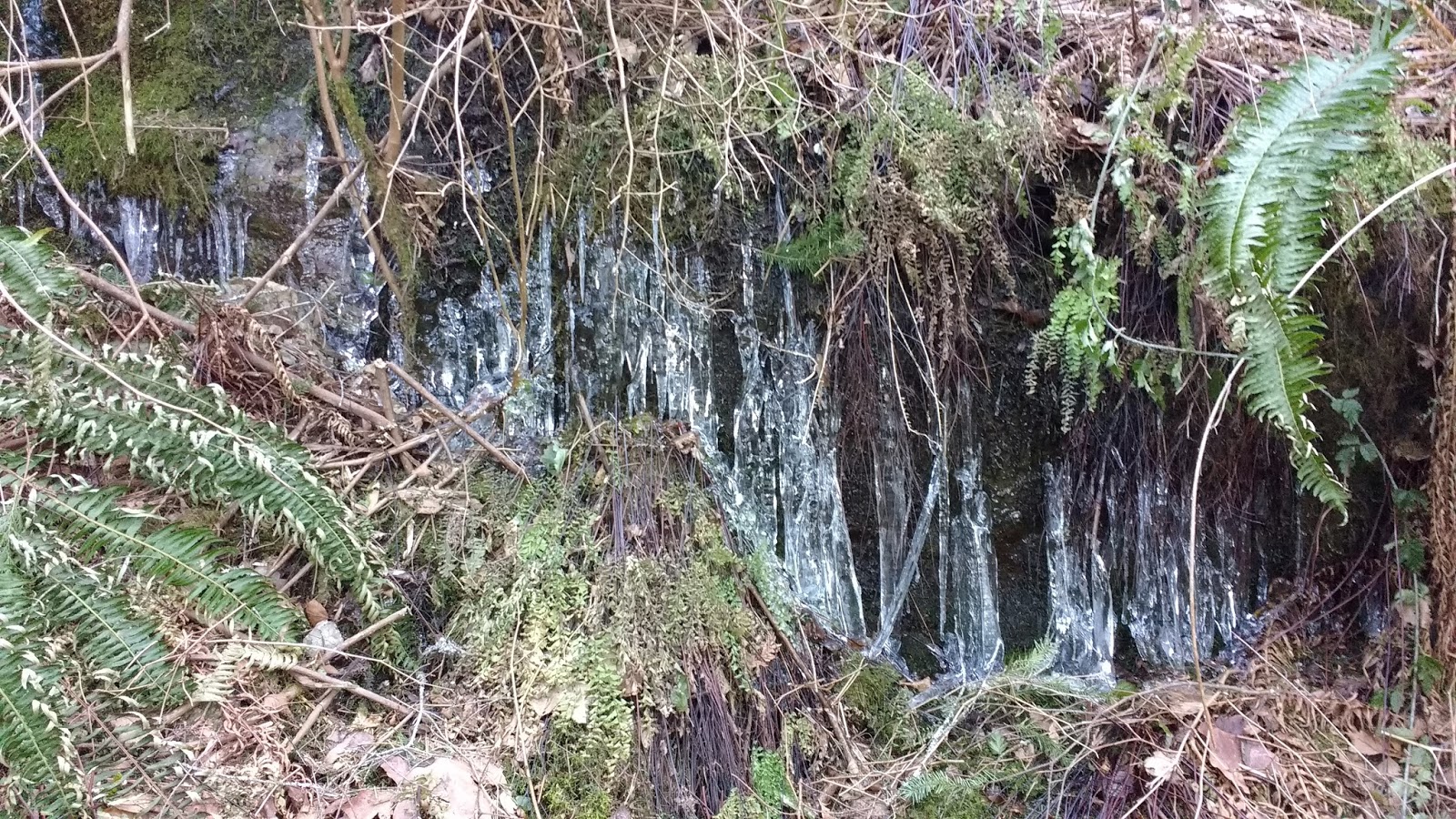
The way back was quite uneventful. I enjoyed the beautiful icicles beside the road, on that lovely wind-free day. ;)

Soon, we were back at the entrance to Crippen Park, where we had started.

After returning home, I enjoyed cheese time, while Colin graded his most recent co-op student.

No comments:
Post a Comment