Today it is 25 degrees Celsius and overcast… It's a great temperature for a hilly hike, but I wonder whether it will rain. We don’t want to get caught out really far away from either the gite or vehicle if it starts pouring... Maybe a forest hike is in order? I scour the map looking for a forest we have not yet hiked.
I suggest a hike near Dième, which is about 10 km West of Chamelet. We have not explored this area much, but the randonnée map shows a forest area called Brou. On the map, "Brou: La Cabane Guérin" is marked in blue on the map, which we have learned means there should be a parking lot there. From there, I plot out a randonnée of about 10 km, with an elevation change of 400m down, then the same back up again.


Word of the Day: massif
massif (ˈmæsiːf ; French masif)
Definitions
noun
- a geologically distinct mass of rock or a series of connected masses forming the peaks of a mountain range
- a topographically high part of the earth's crust that is bounded by faults and may be shifted by tectonic movements
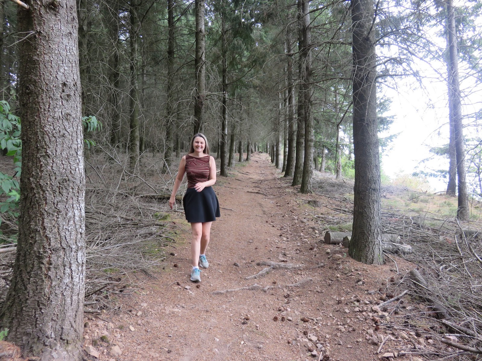
The sign also explains how Brou is a coniferous forest, consisting mainly of Douglas Fir, which were planted here after bad storms damaged 40% of the area's forests in 1999. Other trees, like pines and cherry, were also planted at the same time, for diversity. About 200 hectares of the 1700 hectare forest were replanted after the storms, but the summits were not replanted, due to their susceptibility to wind. This explains why there are so many obviously man-made forests in this area. I had assumed it was all about logging, but this sign gives me a new perspective.
From the sign, we can see the yellow "Brou: Cabane Guérin" randonnée signpost. It directs us towards La Roche Palais, only 200m away. We step off the paved road onto the gravel trail, just beside a red-and-white "do not enter" sign, and another small brown sign announcing La Grande Allée. It doesn't seem so "grand" to me, but it is pretty, in a rustic sort of way.


We soon arrive at La Roche Palais signpost, which directs us onto a rough little path on our right, towards Le Haut de l'Etang and Ruisseau de Brou. The path is overgrown with tall grasses, what Colin is apt to call "tick central," but perhaps his recent tick-free streak has emboldened him, because he is game to walk it today.


Soon, however, the grasses turn dry and brittle, then give way to dirt and needles. The trees around us first disperse to open-air views of the surrounding hills, then close in to a claustrophobic tunnel. Finally, the trail stabilizes into a wide gravel road that drops at a fairly steady rate down to a T-intersection. We take the right fork.


The road stays wide and easy as it continues to drop down steadily to the next T-intersection, where we turn left. The path turns South, and soon we are on a gravel road, running parallel to the Ruisseau (creek) de Dième in the valley below. We get some nice views of the valley and surrounding hills.


The road stays the same through Groly and Les Grandes Roches, as it slowly winds its way South. We are watching for a specific fork on the road where we will have to choose between the official path and another path that could take us more directly to the Ruisseau (creek) de Brou, where we plan to have our picnic lunch. There are several offshoots along this stretch, but they are all less established than the official randonnée path, so it is easy for us to stick on the official path.

When we get to the fork we are looking for (the white dotted line on the map), we pause. It is certainly less established than the road we are already walking on (see right hand fork in photo below), but we are feeling adventurous, so we go for it. It leads us on a gentle downward incline down a series of switchbacks. While we do hit a few patches of light weeds, the trail is really easy to follow, and looking down over the hill to our right, we think we can see the road we are aiming to reach in the valley below. We reach the bottom, and as expected, we hit the road. We turn right and follow it down about 200m to Ruisseau de Brou.


As we approach the Ruisseau de Brou randonnée signpost and picnic area, I notice two women picking what I assume are berries or plants off the side of the road. But there don't seem to be any berry bushes in the vicinity. They look self-conscious as we arrive, and don't even say "Bonjour." Not wanting to stare and make them any more uncomfortable, I can't figure out what it is they are picking.


We sit and eat a baguette and polish off the Tomme Jura we bought in Lamure Sur Azergues. We have been buying a lot of Tomme in Beaujolais. There are dozens of different kinds of Tomme which are each produced in different local areas. Each Tomme is similar, yet unique, reflecting the grasses of the area in which it was made. Tomme Jura comes from... Jura! The Morbier Fruité we bought at the same time as the Tomme Jura didn't last the day--we gobbled it right up. ;) Although the "Fruité" part of its moniker seems to imply there would be fruit in it, it just means the cheese has been aged--it tastes exactly like regular Morbier to me.


By the time we head out again, the two women have left in their car. We head back up the road we just arrived on, and I scan the side of the road where I thought they were, but I don't see anything of note. We pass the exit of the switchback, and stay on the road.
There should be a yellow randonnée signpost here for Le Bas de l'Etang, but I can't find it. Soon we are at the pond, and I know for sure I've missed the signpost. A fence divides the road from the pond, but it is clear that people have beaten a path in the weeds on the South end of the pond. We head in to get a closer look at the pond, and I get a big whiff of mint. Looking down, I realize these "weeds" are all mint plants! Just like in Lamure Sur Azergues, it is growing wild here. Maybe the two women were picking mint??


After viewing the pond, we return to the main road and continue onward. It's a steady uphill incline. We quickly find the Fond de Brou randonnée signpost, where a trail joins the road on the left side.
Checking the signpost arrows, we discover that this is where we would have come out, if we had stayed on the main trail instead of opting for the switchback down to the Ruisseau de Brou. The main trail would have passed through Le Haut Etang instead of dropping down into the valley, and would have saved us a nearly 90m in elevation change. On the other hand, it would have missed the pond and our little picnic area in the valley. It also looks extremely overgrown at this point.
Based on the condition of the main trail, we are feeling pretty proud of ourselves for going "off-book" and forging our own path (even though, based on the condition of both trails, we suspect it is what most people do). We check the signpost for our next destination, La Pierre Blanche, and continue onward along the gravel road.


As we continue to trudge slowly uphill, our smugness wears off and is replaced with a layer of sweat. It's not that the trail is so arduous, but its consistency starts to wear on certain leg muscles that are being used continuously. It also feels hotter than 24 degrees.
I re-check the map: it's actually 150m in elevation up from the Ruisseau de Brou to La Pierre Blanche. 150m of elevation in less than 1.5km of distance. Fatigue brings its friend doubt to the party: Was it really worth the elevation change to picnic in the valley? Was it smart to stop to rest and eat at all? My body seems convinced that "Cheese Time" means the hike is over, and is very upset that it is being asked to trudge up any kind of hill at this point.

Fortunately, this is when I spy a hilarious sign posted beside the trail. "No petting trees" it tells me. It's almost as good as the "No shooting trees" sign I saw at Moorecroft Park near Jan's on Vancouver Island in Canada. I stop and have a good laugh.

[Edit: I found my photo of the "no shooting trees" sign at Moorecroft!!]

At the La Pierre Blanche randonnée sign, we have a decision to make: (1) turn left towards Les Roches Blanches and La Roche Palais back to the camionnette at La Cabane Guérin, which would take us fairly directly back to our starting point, but keep us going another 2km on the same incline we'd just been trudging for the last 1.5 km; or (2) continue onward towards La Font Gelée, a "scenic route" that would take us through the Croix de Brou and spread the incline over a longer 3.5km. Even though it's nearly twice the distance, our calves beg us to take the latter route.
Now we have a second decision to make: which of the two possible forks is actually the one to La Font Gelée?? The leftmost fork appears to be more established, but the randonnée signpost seems to be pointing to the grassy path on the right. The randonnée map seems to say it's the leftmost fork, but it also seems like the two trails might simply rejoin each other in a short while. I don't want to take the risk, and insist on the leftmost fork.

Soon, however, I start to doubt myself, when yet another fork appears. Scrutinizing the map, I declare that this time, we should take the rightmost fork, as the left fork appears to cut off La Font Gelée and the Croix de Brou, dropping us closer to Cret Verrière.

The trail starts to drop downhill. This is confusing, as we are supposed to gain about 30m in elevation along this stretch. As we descend, Colin starts telling me that his GPS is saying we are nowhere near where we should be. Then we encounter the ruins of a house.
There is nothing on my randonnée map indicating ruins in this area. I worry I've led us horribly astray. However, since we're here, we decide to check out the ruins. There is a small hole in a mound (see right side of photo below), and I poke my head in to confirm that it is a well. Behind it is the main house. It is only a shell now, crumbling apart.

We head inside. A few trees have fallen inside, and I wonder whether they are the only reason why the walls are still standing. Upon closer inspection, I realize the house is made of rock and mud. The mud has dried and all but blown away, leaving the piled stones precariously balanced on each other, at the mercy of the next strong wind or rainstorm. However, some metal fixtures like nails and hinges remain, which tell me that this building is not as ancient as it would appear. Still, it does not appear to be very stable, so we don't touch anything and don't stay long.


Exiting the house, it appears that it is actually comprised of two adjacent sections, which share a wall with no windows or doors. It seems strange that one would have to go outside the house to get to the other half of it. We wonder whether one part was for animals. Returning to the path, I notice the ruins of a second house farther back in the bush. It is almost completely covered in vines, and there is no obvious path to it. I would not even have noticed it, if the other house were not here.

As we continue onward, we pass through a stand on conifers, and I am relived to see a road below us, at the angle I would expect. Colin is still convinced we are not where we are supposed to be, but I am reassured. I soon spy a red-and-white randonnée flag painted on a tree indicating a left turn, and just behind that is the La Font Gelée randonnée signpost, hidden inside a stand of trees.


We take the left turn as indicated, while I yell "Victory is mine!!" We exit the forest and walk beside a grassy field until we hit a paved road, and I realize: I've been here before! The Croix de Brou randonnée signpost is to my left and the Croix de Brou itself is to my right. I turn to my right and see the little white portable beside the dirtbike trails.


We turn left at the Croix de Brou signpost to follow the paved road towards Cret Verrière. Nearly 1km later, we reach the Cret Verrière signpost, and continue onward towards Bois de Saint Martin. We are watching for a fork in the road within 0.5km, where we should find the Bois de Saint Martin signpost. Although the map shows that either fork at the signpost will take us back to La Cabane Guérin, we have decided to walk up through the viewpoint at Le Relais, rather than take this second opportunity to go through Les Roches Blanches.


We can't seem to find the Bois de Saint Martin randonnée signpost, although we do see a red-and-yellow randonnée flag painted on a tree on the left hand side of the road, pointing to a nearby trail off to the right of the road. We follow the dirt trail up off the road, and see another flag painted on a tree. I guess this is the fork we're looking for, although I don't see an official yellow randonnée signpost anywhere.


A little farther, the road forks again. Either this fork is on on the map, or we turned off the pavement too early. I can't understand why there would be official randonnée flags, if this were not the correct path, but assuming we are on the earlier trail, we should take the left fork here, so we do. Our guess is soon confirmed by a red-and-yellow randonnée flag painted on a tree.

Next, we encounter another fork, and I am at a loss, until Colin notices the Le Relais yellow randonnée signpost propped up in a small stand of Oaks (look carefully on the left side of the photo below). It appears that the post had at some point been uprooted from the ground, and a kind soul propped it up with the trail arrows pointing in the appropriate directions. Although the signpost doesn't mention La Font Davy, the map is telling me that if we turn right here, we can get to La Font Davy--the signpost that gave us such trouble on our first hike in this area.

I look around for the "viewpoint" advertised on the randonnée map. It is nowhere to be found. A little disappointed, we follow the arrow onward towards La Cabane Guérin. The trail here is fairly flat, running straight as an arrow through perfectly aligned fir trees. Colin motors ahead. He is ready for the walk to be finished. "Hey, look over here," I call out to Colin, as the trail opens on one side to the valley below.


The views are great, running 180 degrees, and there is a plaque identifying nearby hills and towns. The hill directly in front of us is the 710m Mont Chatard. The dirtbike trail and the Croix de Brou are visible on its left side. Using the zoom on my camera, I am surprised to see both the Tower of Oingt (in the East) and the Matagrin Tower and radio relay tower (in the West), which are 33km apart. Then we feel a couple drops of rain, so we pick up the pace as we head into the last stretch.


A little over a half a kilometre later, the path drops us onto a paved road. A yellow painted randonnée flag painted on a tree tells us to turn left onto the paved road. At the road, there is a small wooden sign saying "Table d'Orientation" is also in the same direction. As we turn left, we can see the camionnette up ahead in the parking lot. I'm guessing that the "Table d'Orientation" is the map and info board I read at the start of this hike.


The couple who had been barbecuing here when we left have long since disappeared, but seeing the picnic table cues my stomach to start grumbling. Time to head to the gite for Cheese Time!

For Cheese Time today (of course the earlier cheese-eating at Ruisseau de Brou was not "Cheese Time," it was "lunch"!), we have Brie de Meaux, Jan's fave. She ate her share of it when she visited Colin in June (while I was in Paris). Brie de Meaux is similar to Reblochon, one of our host Alban's favorite cheeses. Both cheeses are supposed to be eaten at room temperature, at which point they are soft like butter. Alban told us we had to leave the Reblochon out on the counter at least 6 hours before eating it. Canadians would freak out at that... our "foodsafe" rules say to toss out proteins as hopelessly inedible after two hours out of the refrigerator. I think most French people would simply refuse to eat the too-young, chalky tasting, chilled soft cheeses we eat in Canada. For them, this would be considered hopelessly inedible. ;)

Fun fact: "reblocher"" means "to pinch a cow's udder again." Now that might sound really kinky, but apparently, it simply refers to the practice of not fully milking the cow at milking time, then returning later to finish the job. In the 14th Century, farmers were taxed according to milk yield, so it only makes sense some of them would try to get a "tax break" by making it seem like the cows gave less milk. Later, after the milk yields were tallied, they would re-milk the cows and use that second, richer, batch of milk to make reblochon cheese for themselves. Once you've tried this cheese, you understand the impulse...
No comments:
Post a Comment