This morning we're on a mission to get more croissants. I refuse to end our trip croissant-less. Yesterday's attempts to get croissants were dismal: our usual bakery in Ternand was closed, with a sign on the door saying, "Away July 21-Aug 11," and the bakery in Allières, 4.5 km to the North of Chamelet, was also inexplicably closed when it was scheduled to be open. The lights were on and we could see bread on the counters, but the doors were locked and there was no handwritten note to tell us what's going on. Ah, France...
Today, we try again at the bakery in Allières. As we enter the town, a sign screams at us to slow down and "think of the children!" Of course, I hear it in Helen Lovejoy's voice. This time the bakery is open, but their croissants don't look fantastic, so we only get two and hope to find more at another bakery. (Their pain au chocolat, on the other hand, look amazing today, so we also get two of those.)


Colin says he saw a bakery in Lamure Sur Azèrgues when his family was visiting last month, so we continue on the highway another 5.5 km North. As we drive, Colin suggests, "Why don't we randonnée out in that area today?" I say, "Sure, but I don't have a map for that area, so I don't really know what is there." He says he knows a place in town where they have a randonnée map like ours for sale. Sounds perfect!
We arrive in Lamure Sur Azèrgues, looking for the Tourism Info Office near the center of town. We turn right at the big gold-colored Mairie, but finding parking is difficult today: the large public parking lot is being filled by the town Market.


We turn right again at the market, and finally find a parking spot by the side of the road. We walk a block to the Tourism Info Office. Inside, a lady and man are chatting. I pull out our randonnée map and ask if they have one like it for this area. The lady says, "like this one?" and gestures to the map on the wall behind her. "Yes!!" I exclaim. She glances at the man and replies, "We have it but I can't sell it to you. There are some changes happening with who is allowed to sell it, so I can't sell any until the paperwork goes through." I am dumfounded. She looks apologetic. "I can give you this one... It's not a map, but it describes hikes in the area." She hands me a booklet very similar to the one I bought in Oingt. This one is bigger with more hikes listed, and it's professionally printed. Not bad! After we walk out, I notice it has a 3 Euro price tag on the back. Not bad at all!! I just wish it showed the surrounding trails too, for context.

Heading back to the camionnette, we stop at the bakery: the red building to the left of the Mairie. They have a small pile of great-looking croissants!! We ask for eight, which should cover all our breakfasts until we leave. The clerk gives us an incredulous look and repeats, "You want EIGHT?!" Apparently this is an odd order.
Very happy with our purchase, we next check out the Market. It's a decent size with many stalls. It seems like we are catching it just as it's closing. The church bells are pealing noon, even if it's not quite noon by our cell phones. We wander down an aisle of clothes and household items, but nothing catches our eye. Then Colin notices one head of iceberg lettuce sitting all alone on a table. It's marked as 1.20 Euro. We decide to buy it, since the last two trips to the Intermarché supermarket in Allières have left us high and dry for lettuce. We indicate to the vendor that we want to buy it, and he says, "90 centimes... No, wait, 80 centimes... Look, the stem is a bit brown." We're on a roll today!!
Very happy with our purchase, we next check out the Market. It's a decent size with many stalls. It seems like we are catching it just as it's closing. The church bells are pealing noon, even if it's not quite noon by our cell phones. We wander down an aisle of clothes and household items, but nothing catches our eye. Then Colin notices one head of iceberg lettuce sitting all alone on a table. It's marked as 1.20 Euro. We decide to buy it, since the last two trips to the Intermarché supermarket in Allières have left us high and dry for lettuce. We indicate to the vendor that we want to buy it, and he says, "90 centimes... No, wait, 80 centimes... Look, the stem is a bit brown." We're on a roll today!!


Now, you may be wondering, "If there is a grocery store in Allières, and you have been going to it regularly, why don't you just buy croissants there?" Excellent question, my friend!! The answer is, that grocery store does not carry croissants. You might think it is one of those quirks of French shopping, like: while you can buy beer and wine at the grocery store, you cannot buy aspirin there. For that, you must go to the Pharmacy. We thought that must be the case for croissants too, until we went to the grocery in Villefranche Sur Saone, where you can buy croissants. Sooo... yeah: because France.
The last stall of the market has cheese, and we can't resist. We buy a wedge of Tomme and a wedge of Morbier. I tear a hunk off the Morbier and pore over the map booklet on our short walk back to the camionnette. "You know, there is an 8.5 km hike that starts right near the market!" We drop our goodies off at the camionnette, and head back to the Mairie. Sure enough, there is a yellow randonnée signpost, aptly named La Mairie. There is also a sign with a randonnée map printed on it, complete with topography. I take a photo of it, for reference. Now, we're set!

The 8.5 km randonnée I select is called "Circuit Bleu," and it will take us to the Fountain of the 3 Notaires in the Foret de la Pyramide. It seems like a slow elevation rise of about 317m over 3.5 km up to the Fountain, then a nice stroll along the top of a rise, before another slow descent back to the start. The rainstorm yesterday seems to have reset the weather, as today is 23 degrees and overcast... Perfect for a longer walk (and for leaving groceries in the car).

Just over the green fence from the randonnée signpost, the Azergues river rolls lazily past. The randonnée signpost lists La Cime du Bourg, which we assume is the same as La Cimetière, the next signpost on the randonnée map. We follow its directions back up to the Market, where there is a war memorial and some city signs.


At the memorial, we take a right and head towards the church we can see about a block away. We cross the railway tracks and find the Cime du Bourg randonnée signpost. It points us onward to Le Cimetière, so head up a short curved incline towards the church. Rechecking the map, I realize, yep, there are two separate randonnée signposts (Cime du Bourg and La Cimetière) that I had somehow conflated.


Now back on track, we approach the church and circle around its right side to a stone cross that is not mentioned on the map or in the booklet we got from the Info Office. We are slightly worried that we've somehow taken a wrong turn, but the booklet says that after the church we head to Biconne, and all signage (including one specifically for Biconne) seems to point in this direction, so we continue onward.


Past the church, there is a lovely stone wall, whose gate reads "Notre Dame de Fourvière" in light blue letters. I am confused: this seems fairly far from the Basilica of Notre Dame de Fourvière we visited in Lyon. Are they somehow related? I have no idea. Just around the corner, the path takes us past the cemetery to the Cimetière randonnée signpost, which directs us down the road towards Les Jacquetières. A cow catches my eye in the field beyond, and as I approach, I notice a blue plastic stag's head with a yellow arrow. Aha! Circuit Bleu! I get it now.


We pass the cow and follow the blue stag down the road to Biconne. At the T-junction, a city sign points us right, towards Biconne and Les Jactières (which we assume is the same place as Les Jacquetières). Just around the corner, a large water tank trailer sits on the left side of the road (not shown), while this little hobbit-sized door sits on the right side. OH-- I just put it together now--this is probably a water well, not a secret underground home for tiny people.


We enter Biconne, which appears to consists of one farm, straddling the road. It reminds me of the farm where Ares hid out on an episode of Xena: Warrior Princess. As we pass through, I find the answer to the age old question: "Why did the chicken cross the road?" It's because the rooster escorted her across! We stop and wait for three hens to hesitantly cross the road while a rooster stands watchful guard. Once all the chickens finish crossing the road, we advance. The rooster sees us and boots it up the road towards a driveway where a tiny little black dog barks at us menacingly. (Did I say menacingly? I meant endearingly--he is not at all threatening.) I think I'm starting to get how the "pecking order" works at this farm! The rooster protects the hens, and the dog protects the rooster... I wonder who "protects" the dog?


As if in answer to my question, a goat pops his head over the fence just past the driveway. What timing! ;) Looking to the field on the right side of the road, a group of cows are lazing in the sun. Then I notice a goose hanging out among them. While I laugh at this quite amicable animal diversity, Colin exclaims, "What is that in the field?! A rat?" Nope. It's a tiny wobbly kitten, heading toward the group of cows. This farm is seriously some kind of animal cooperative utopia.


On the path after Biconne, I find a pile of Great Spotted Woodpecker feathers. Sadly, there are far too many to believe the bird could have survived its mishap. I select a few nice feathers to take with me. I also find some lovely black white and blue Jay wing feathers. (Thanks again to Alex for giving me "Pocket Birds of Britain and Europe"... it has once again easily identified my birds! Note that the photo below also has a few other feathers--likely dove--mixed in.)

Soon later, the paved road turns right, but a post with a blue stag's head points us to the slim gravel path on the left. We estimate we are about 1.5 km from the Les Jacquetières signpost, so we keep an eye out for trails forking to our right. Unfortunately, there are two before we finally get to the signpost. We spend a lot of time at each one, debating whether it is the correct path or not. Looking at the map, it seems like taking the first of the two would bring us back to this trail at the second of the two, and pass by a spring on the Ruisseau de Biconne. We stick to the main path past both of them.


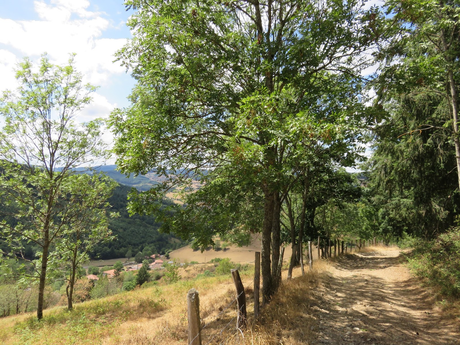
Although the path starts out narrow and grassy, it opens up as we head through the trees. There is a lot of pine, fir, and juniper here. I love the pine. Many of our hikes, like today's, smell of pine. It's funny there is not much cedar here. Earlier this month, I managed to pick a few sprigs of nice cedar from the side of the road.

After the forest, we end up high above the valley we just walked. Here, the path is bordered by blackberry bushes. This sure is a great hike for edibles! :) The views from this vantage are also great. Looking down, we can see the path we took through the valley far below us; looking around, we see the tops of the neighboring hills.


There are a couple of trails heading off to the right of our path, but we stay left and continue onward. At each one, a sign with a a blue stag head guides us.

The path curves to the right, and we find ourselves overlooking a valley with the hamlets of Verbifière. It is very picturesque. Where the road bends at Borsat, we pass a house with a swimming pool... it is bright blue and sparkles in the sun. We fantasize about jumping in, and affirm that we would definitely get some kind of pool if we owned a house in this area.

A little farther along, we pass through the moto-cross area. I can see giant tires lining the ridge above my head on the right, and a maze of trails below me to my left. Looking over the valley, we also spot an interesting apartment-like complex, its roof covered in solar panels. It seems really out of place here, amongst the farms and small houses. I would say the moto-cross is also out of place here, except we have encountered dirt bikes on many of the trails we have hiked in Beaujolais.


Approaching the centre of the moto-cross trails is an intersection of many dirt roads. The Croix de Borsat is just on the other side of the intersection. We walk straight to the cross, then look back at the trail we just walked (on the left of the photo). Opposite the cross is an unlabeled yellow randonnée signpost that points us towards Cimetière and Lamure Sur Azergues.


Just beyond this point, both the forest and the cement start up again, but we quickly veer off the paved road and back into the forest, as directed by a small post with a blue stag's head. A couple minutes later, we hear the familiar roaring sound of a dirtbike, and jump to the grassy shoulder as a rider screams past.


Soon we are back at the Cimetière signpost and walk beside the cemetery to the church. A white arrow on a blue road sign directs us to go right around the church, so we shrug and say, "Why not?" Either way will take us around, and now we've done the full circle.


Instead of taking the winding road down to the railroad tracks to return exactly the way we came, this time we cross the tracks on an overhead pedestrian walkway. We can see the camionette waiting for us on the street below. It's time to go back to the gite for Cheese Time and a little rest, since we have a 11 km hike to do this evening, to get to our supper at the Le Cep Vert restaurant in Létra. I'll save that randonnée for the next blog entry. ;)


No comments:
Post a Comment