Dec 3, 2016
We were just about to head out on our walk, when Ben called to say he intended to be over on the 12pm ferry. If he made the ferry, we could take him and his son on a hike.
Well, true to island life, he missed 12:00 ferry. :p So far, everyone we knew who had tried to make the 12pm ferry had missed it, and had to wait for the 2:30pm. I think we will start warning people not to aim for that particular ferry. ;)
Well, true to island life, he missed 12:00 ferry. :p So far, everyone we knew who had tried to make the 12pm ferry had missed it, and had to wait for the 2:30pm. I think we will start warning people not to aim for that particular ferry. ;)
So we dropped off some stuff at the BIRD (recycling depot), and drove to where Grafton Rd turned into Adams Rd. Since it is the main thoroughfare of the island, all the approaching traffic assumed we would continue through the right turn and onto Adams Rd, so we had to wait three cars before they caught on that we actually wanted to go straight, onto Cowan Rd. We eventually got through the intersection and onto Cowan Rd, where we immediately parked the car (I marked the spot with a red "P" and a red dot on my hiking map below). Willie's Way led off to the right, and Cowan Rd was on the left.


We planned to walk up Cowan Rd until we hit the trail, then take the trail through Athletic Park to the road, where we would turn left, and follow Salal Dr to Cowan Point Dr, turn right, and by so doing, 3/4 circle the lake. We'd then decide whether to continue onward to Quarry Park to loop around some trails a while, or just turn back, and walk through Headwaters Park, then Athletic Park, and take the trail to Willie's Way back to the car. As you'll see, we did a little side trail to the lake, turned around when we hit a gate (G), then decided to hoof it back through Headwaters Park on the return trip, and didn't spend any extra time in Quarry Park. We ended up with a total of approx 4.5 km.

As you can see from this little screenshot I took of a section of the bowentrails.ca map below, this area had a lot of interlocking trails. One could connect to the Trans-Island Trail along Grafton Rd (running more or less horizontally across the top of the map), and to the Mt Gardner trail system (top left), as well as head down through Athletic Park, Headwaters Park, and finally Quarry Park (at the bottom right of the map). Although it did not show on the bowentrails map, I believe the trail I saw running along Cowan Point Dr also connected this network to the Golf Course.


(click map to zoom)
We started off heading up a very steep gravel hill. A sign said "4wd only." It was fine for walking, and Google maps showed that we could drive through, but there is no way our truck would make it up this road!


This was technically the entrance to Athletic Park. Many people don't know how Athletic Park got its name. According to a BIM document: "An 8.1 hectare (20 acre) site was dedicated to the municipality in 2002. Intent at the time was for site to be used for future elementary school and playing fields. Development of site, however, did not proceed and site was never rezoned from its existing rural residential land use designation. At the Council meeting of 14th December, 2015, Gary Anderson presented a proposal to Council to use a portion of the site for a logging show."
This motion was eventually approved, and the Bowen Island Loggers Sports Group volunteered to create a 1.5 acre field, which would still be municipally owned, but could be used (with permission) by community groups, including, of course, the Loggers for their sporting events. It appears that as of August 2016, the Bowen Logger Show was in place at the new site. We hoped to see the venue as we passed through the park.
We saw the trail heading to a cute little bridge, where it merged with a gravel road, but also noticed a sign saying "Keep Off Bridge." We were momentarily stumped, before noticing a second, smaller bridge off to the left of the first one.


The path walked through a neat "hallway" of young trees, and gave us intermittent views of the lake.

Beside the "Road Closed" sign, we saw the trail, heading into the woods on the right side of the road. It was fairly wide, level, and graveled.

This was technically the entrance to Athletic Park. Many people don't know how Athletic Park got its name. According to a BIM document: "An 8.1 hectare (20 acre) site was dedicated to the municipality in 2002. Intent at the time was for site to be used for future elementary school and playing fields. Development of site, however, did not proceed and site was never rezoned from its existing rural residential land use designation. At the Council meeting of 14th December, 2015, Gary Anderson presented a proposal to Council to use a portion of the site for a logging show."
This motion was eventually approved, and the Bowen Island Loggers Sports Group volunteered to create a 1.5 acre field, which would still be municipally owned, but could be used (with permission) by community groups, including, of course, the Loggers for their sporting events. It appears that as of August 2016, the Bowen Logger Show was in place at the new site. We hoped to see the venue as we passed through the park.
We saw the trail heading to a cute little bridge, where it merged with a gravel road, but also noticed a sign saying "Keep Off Bridge." We were momentarily stumped, before noticing a second, smaller bridge off to the left of the first one.


After negotiating a fallen log on the footpath, we were on the little footbridge and over the small creek. On the other side, the trail quickly diverged from the gravel road again. I supposed that the other bridge was a driveway access for the nearby house.


At that point, the trail was marked with a sign, and so we followed it. very quickly, we encountered a smaller unmarked path heading off to the left. I wasn't sure whether it was a shortcut, or a completely different path, so we stuck to the trail we were on, and soon arrived at a marked intersection.


To the right was a teal-colored pipe. That was the trail to Willie's Way, which we planned to take on the way back, at the end of our hike. So we took the path to the left, continuing on through Athletic Park. Very soon after that, the small trail we had seen earlier merged with ours. I guess it was a shortcut after all.


The trail ran fairly straight through the forest, however, this stretch suddenly got very wet and muddy.


We chatted and walked a little while, then the trail swung right, and we could see the road straight ahead through the trees. I double-checked the map, and the trail did indeed swing around on itself like a question mark, before exiting onto the road.

Arriving at Althetic Park Road, which marked the official end of Athletic Park, we realized that we had somehow missed the Logger's "athletic park."

Looking at the plan provided on the BIM document later, we realized we should have passed the field, but then realized that the "access" was planned for farther up Athletic Park Rd. I supposed that for some reason, they chose not to attach the walking trail to the event area after all.

Directly on the other side of the road from where we exited Athletic Park, a trail sign marked the entry to Headwaters Park. However, we decided to turn left and walk along Athletic Park Rd towards Salal Rd, and circle Josephine Lake before coming back this way through Headwaters Park.

About 150m later, we saw the intersection with Salad Rd, where we had planned to turn right. However, just at the corner, we saw a very well-established unmarked trail running parallel to Salal Rd. We decided that it would be much nicer than the road, and if it ended up being private property, we would just turn back.


The path walked through a neat "hallway" of young trees, and gave us intermittent views of the lake.
As we walked, Colin wondered whether this felt like France. Yes and no, he mused. Definitely, the rain didn't feel like our summer there. ;) And there were far fewer ferns in France, he laughed. But the routine of getting up, eating, and going for a walk together, felt familiar.


We got a nice view of the lake, but at one point we were stopped by a fence. A sign read "Protected Water Reservoir: No Unauthorized Access Beyond this Point." Peering over the fence, I got one last view of the lake, and could see a little house peeking out over the opposite end.


I checked the GPS... we were really not where I expected to be. I had thought that the trail would lead us parallel to Salal Rd, but somehow, it had cut across at a 45 degree angle and put us on the opposite side of the lake. We retraced our steps back to the intersection at Salal Rd.


Walking on Salal road, there was no shoulder, but also no traffic. It started to rain lightly. Colin mused that this area didn't feel like Bowen: there were small trees and open sky! ;)


We saw a Stellar's Jay and a whole whack of teeny birds scurrying around at the road's edge. (Just now I wondered why we say "a whack" to mean "a lot" and googled it. Had no success finding the original usage, but turns out it's a Canadian thing--who knew?? lol. I find that hilarious. BTW, never knew that "keener," "for sure," and "icing sugar" are pretty much unknown outside Canada.)


We paused for a car as we approached Cowen Point Rd. Until that point, we had no problem walking on the small country roads, but suddenly there were a lot of cars passing by, near that intersection.

The trail followed the road, separated by cement safety barriers. I suddenly realized that this was the trail I saw when driving from the golf course!

Looking down near the corner, I saw an interesting little platform above Josephine Creek (yep the same one that extends through the golf course). The platform resembled a raptor feeding station-- like the one we used at Graycliff Cottage on Vancouver Island-- except it was so close to the ground.

A little farther down the road, I spied a pretty waterfall through the brush.

A little later, I spied a small dam, which marked the southern end of Josephine Lake. It turns out that the dam had been built in 2007, as part of the infrastructure to support the the Cowan Point subdivision centered around the golf course.

Walking along the road like this felt a LOT like much of the road walking I did on the Camino Primitivo.
The trail continued beside the pavement. We passed Jophine Rd, and headed downhill. A rooster crowed. On Bowen Island, it is not uncommon to raise chickens and do local farming/gardening. The on-island pet store stocks chicken supplies right beside the doggie food.


We arrived at the cross walk between Quarry Park & Headwater Park. Both parks were marked with big titular signs. There was a small parking lot, at the entrance to Quarry Park, on the left. I marked it with a red "P" on the map above.


A matter of metres along the trail, the trail split, at a sign with a park map and some info about the park. It told us that the 15 hectare Headwaters Park contained the headwaters of two streams, which both emptied into Grafton Lake, the watershed for Snug Cove. The Northern end of the park was marked as "private property: designated future park." Private land to became public! That was a neat revelation! Usually it's the other way around. :) However, I wondered at the date of the map, since it appeared that the trail was already built...

Due to the time of day, we took the right to save time on our return trip, because Ben was arriving on the 2:30pm ferry. It seemed to be a more direct route. (Note the other possible route, in orange dashes, on my map above.)

The trail was close to houses on the right side. There was just forest on the left side. Sooner than we expected, we saw a boardwalk leading off to the left. It was the Wetland Boardwalk Trail. I suggested we go in for a peek, since we seemed to be ahead of schedule.


The map noted that there would be two boardwaks, both with views. I crossed the first one, and saw no "view" to speak of. It merely overlooked a marshy area. Past the boardwalk, the trail entered the trees. It was actually fairly dark in there. Colin called me back: "We don't have time!" So I returned to the main trail and we continued onward.


Reaching another fork in the trail, we took the right-hand fork, as the left-hand trail would merely lead us in a loop back around to the other side of the boardwalk trail. A chipmunk chittered at us, before alighting back into the trees.

Very soon we were back at Athlectic Park Rd, right where we had emerged previously.

Across the road, I easily recognized the trail back through Athletic Park: it was marked with two large stones.

I fell in love with the green mosses and red toadstools of this log's ecosystem.


The path back through Athletic Park was relatively uneventful, until we hit the mud patch again. Below, Colin caught me trying to navigate the mud and water.


When we reached the "shortcut" that we didn't take last time, I knew we were very close to the turnoff to go to Willie's Way. The shortcut is the path directly ahead in the photo below; the real trail is the one leading off to the left. On the way in, it didn't matter which one we took, but heading back, we wanted to go a different way, so we had to pick the left-hand trail.

Just as I expected, we very shortly met with the trail sign. It pointed both left and right, but I knew we wanted to go straight.

I double-checked for the teal drainage pipe, and sure enough, there it was, just past the sign. This trail was much better tended than the Cowan Rd route we had originally taken. The colors were just so beautiful, I was stopping every few feet to capture more greenery.


The trail meandered a slight downhill, until we encountered the creek. We got a great view of it, as it ran parallel to the trail for a bit. Then we arrived at a bridge.


After crossing the bridge, we turned left, and the trail soon ran along a fence.


We exited into a paved driveway. I looked back at where we had come out. I don't think I would have been able to find this trail easily, had I been walking in the other direction. There was indeed an official trail sign, practically hidden behind some branches beside the gate. I couldn't find a number for the house, but a big wooden sign on the gate read "Missy." (Edit: it would be April before I realized what that meant!)


We walked down the driveway, and arrived at an intersection. The street signs claimed we were on Sawmill Lane.

There was ZERO chance I would have found this trail, if I had been walking the other way! bowentrails.ca showed the trail leading from Willie's Way! (I marked that in tiny red dots on my map above.) As I turned around at the Y-shaped intersection and looked back the way I had come: Willie's Way was the road on the left, and we had just exited from the road on the right!

The last downhill, along Willie's Way, revealed a nice view of Mt Gardner.

Just as we got into our car, it started to rain again. What fortuitous timing! Colin checked his phone, and Ben had made the 2:30pm ferry. Again, we were right on schedule. He would be arriving at our place right after us.

Since Ben and his son arrived so late in the day, we couldn't take them on any significant hikes before dark. However, fortunately, that night was the "Light Up Bowen" festival, and we invited them to come with us after dinner. They seemed to really like the idea.


Colin started making dinner. Fortunately, we had taken a trip out to "Villefranche," aka Park Royal, a couple of nights before, to buy groceries, liquor, and various sundries. So we were uncharacteristically set for guests. ;)
Ben's son was keen to check out the trails on our property. I saw Ben and his son heading out through our back trails, and looking confused, so I slipped on my boat shoes to run out after them and give some directions. The trail that (at first glance) looks like the main one is currently blocked with plant debris-- they needed to turn left instead and duck through a small tree tunnel to get to the public Cates Hill trail.

Well, after pointing out all the various trails, and leading them to the public trail, I ended up accompanying them all the way to Davies Creek, and then took the opportunity to explore a path I had not yet investigated, along Davies Creek. I'm estimating it to be about 300m long, each way. In the map below, I've marked the Davies Creek trail in orange, and the rest of the Cates Hill Trail in dotted orange, so as to protect the locations of our personal trails, while allowing you to see how to get to the Davies Creek trail from the Cates Hill public trail. Just for convenience, I've also marked the "Light Up Bowen" festival route in blue on the same map. The blue route is about 1 km total.


Well, after pointing out all the various trails, and leading them to the public trail, I ended up accompanying them all the way to Davies Creek, and then took the opportunity to explore a path I had not yet investigated, along Davies Creek. I'm estimating it to be about 300m long, each way. In the map below, I've marked the Davies Creek trail in orange, and the rest of the Cates Hill Trail in dotted orange, so as to protect the locations of our personal trails, while allowing you to see how to get to the Davies Creek trail from the Cates Hill public trail. Just for convenience, I've also marked the "Light Up Bowen" festival route in blue on the same map. The blue route is about 1 km total.

(click map to zoom)
Together, we walked to where the trail crosses the creek. (I'm going to reuse a few photos here, to refresh your memory of that trail, since I didn't take any new photos on this day until we got past the stairs.)

Here, we could see across the creek to the opposite bank: the trail to Valhalla leading up, and the trail I would soon take to Dorman Rd, heading down.

At the fork, we kept left to go to the creek, as the right hand fork would take us up to Cates Hill Rd.


At the creek, Ben's son urged us onward, bravely leaping across the running water. We navigated our way through the little tributaries to the stone steps I had seen previously, on my hike to Valhalla. Fortunately, Ben's son was wearing boots. Unfortunately, I was not, though I somehow made it through without getting wet.


Just down the steps, there was a little clearing with a safe access to the creek. (I swear I took a photo of these stairs, looking up at them, but I can't find it now. This photo does not really show how elaborate, well-built, and all-around cool they are.)

Here's a photo of the stairs that I took later, from the other side of the creek.

While Ben's son experimented with how quickly various flora floated down the currents of Davies Creek, I ran the length of the trail along the creek, curious to see whether it would come out near the mail boxes on Dorman Rd, near the Crippen Park entrance.

The trail led a little bit uphill (obviously not as steeply uphill as the Valhalla trail), and after crossing yet another little tributary, soon I could see the creek fairly far below me to my left. The ground plunged a little too steeply for my comfort, off the left-hand side of the trail.


Then the trail itself started plunging downwards. It was narrow and slippery, but I was rushing because I knew it would be dark soon.


Suddenly, I could see Dorman Rd up ahead through the trees.

The trail was quite unnerving... narrow, slippery, steep, with a sheer drop-off to the creek on the left.

Twisted and slimy roots emerged like creepy fingers and threatened to grab me and suck me underground. I moved more slowly and carefully, keeping my eyes on the prize.

I ducked under a very low log that had fallen over the path some time ago. I was surprised that no-one had cut a path through it, as I had seen on other trails.

Soon after that, I lost the trail in underbrush... I had gotten within a couple metres of the mailboxes on Dorman Rd. I couldn't figure out whether there had been some recent tree-falls that had obscured the path, or whether everyone just bushwacked their own way to the road from here... or whether I just couldn't find the trail in the fading light.

Turning around, I realized the trail was much more daunting on the way back. It was difficult to see, and I was glad that I had just come down it, because I was not sure I could have found it otherwise. I remembered passing this big tree (see photo below) and headed for it.

Here's another photo of the trail, looking up, as I headed away from Dorman Rd. The trail was all but invisible, even though, having just come down it, I knew where it was.

The trail was steep and slippery. I really should have worn my runners, instead of my slip-on water shoes. Lol. But the light was fading, so I hoofed it back as quickly as I safely could. After the first ascent away from Dorman Rd, the trail became much easier to follow. I met up with Ben and his son just on the other side of the creek. They had followed me a little ways, but after seeing the condition of the trail, had turned back. Smart move.
We warmed up by sharing some "virtual" Lagavulin with Ron Swanson by his (also virtual) fireplace, and then chowed down on the lovely salmon Colin had prepared.


After dinner, it was time for Light Up Bowen. We walked through the right-of-way cut-thoughs to the Ruddy Potato in Village Square (marked VS on the map above). There, we were fed cookies and hot cider, while Christmas carolers (Bowen's own Men on The Rock Choir) sang. Then the Black Sheep Dancers put on a show (here's one they did in Vancouver, as an example). It seemed like the whole island was there, with bells on... their umbrellas! ;) Ben's son got given a glow-stick necklace, to his delight.


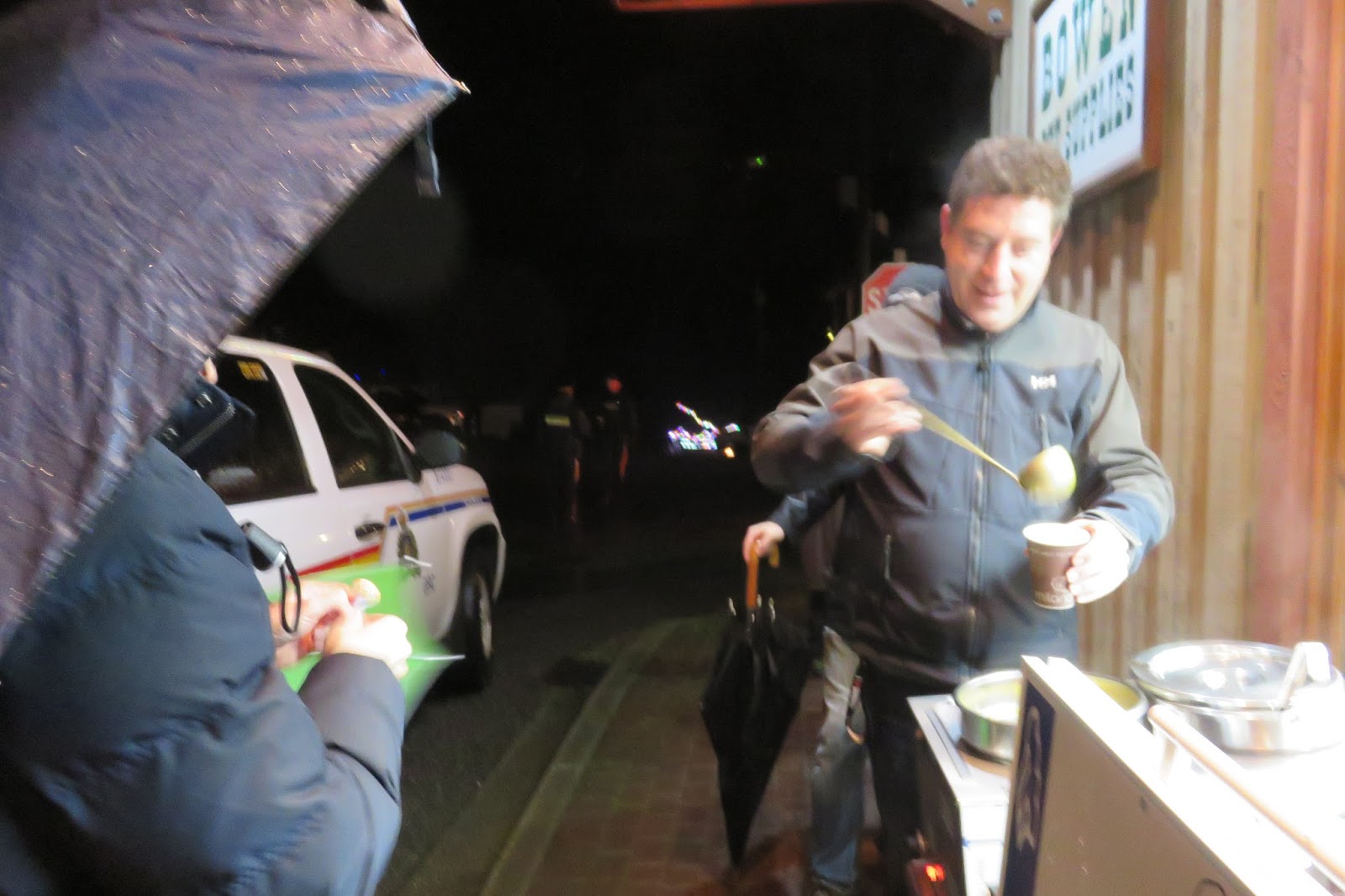
The pet store handed out lolly pops. The Soup Fairy at the Village Bakery Cafe handed out two types of soup. Now, I can't confirm that this particular soup server was an ACTUAL supernatural being, but the soup was sure magical! ;)
We followed the parade out from Village Square, across Dorman Rd, and down Davies Rd. The way had been lit up with festive lights. At the baseball field, volunteers guided us around giant puddles and along the edge of the field to Davies Orchard Cabins, and we exited into Bowen Island Trunk Rd, beside Tuscany Pizza, whose staff was there offering gooey chocolate chip cookies to passerby.


Many people were dressed up and adorned with lights. Others held lanterns (I assume many were made at Tammy Brockmeyer's workshop on Nov 29). I felt sorry for a young man dressed in a Black Sheep Dancers outfit, whose black makeup was all but melted off his face in the rain (not shown). Poor guy looked soaked. I guess it's hard for them to do their dance under umbreallas... ;) Although some other people seemed to be giving it a go... XD

Upstairs from Out Of the Blue Boutique and Bowen Barber Shop, performers from Cates Hill Chapel put on a live Nativity Scene outside the windows of the Notary and Real Estate Offices. Out Of the Blue handed out sugar cookies and cocoa.

Heading down towards the ferry terminal, we were offered shortbread from Nature Encounter Tours, and eggnog and animal crackers at the Connie Wright Original Knits Boutique. We were feeling a bit of a sugar high, I must admit!
Down at the intersection of Cardena Rd, we waited for the firing of the anvil (marked "A" on the map above). A firetruck was there, and the road was somewhat blocked off for the occasion, although cars still could board the ferry as needed.

We all held our breath as a car drove right by the anvil, right after the fuse was lit... But fortunately for that car, the anvil didn't fire. The crew proclaimed it a dud, and the good-natured crowd yelled "bang!" as a group, before wandering off towards the big party at Doc Morgan's Pub (marked "D" on the map above). At one point, I overheard one woman say that one year, the anvil actually landed on a car's hood, after they drove too close to it while it was firing. Apparently it did a lot of damage.

To get to Doc's via the marina, we passed by a beautiful collection of Christmas trees, each decorated by a different local company or community group. Behind the trees, the USSC building was also lit up in white lights. (I marked this with a mini Christmas tree icon on the map above-- go ahead and zoom in on the map, if you haven't already, as I'm pretty proud of that tiny tree icon. lol).

Doc's huge downstairs patio was packed with tables, overflowing with goodies and warm beverages... not to mention warm bodies. A man asks if I want cocoa or mulled wine, and when I answer "Mulled Wine??? Mulled Wine!" He directs me over to the other end of his table, where, to my surprise, my realtor was cheerfully filling cups.

Soon after, it was announced that Santa arrived on a tug boat festooned with lights. Children ran over and screamed as if the Beatles had arrived. (Did you see the mini-Santa in his tug on my map above? lololololol)


The festivities completed, Ben needed to get back to his car and then drive to the ferry. So we continued along the boardwalk until we reached the big field in Crippen Park. Crossing the field, and passing the picnic tables, we exited the park back on Dorman Rd, right across from where my trail adventures had led me a few hours earlier.
It was too dark to look for an entry to the trail, and besides that, I strongly advised against trying to take it home in the dark, that very wet evening. So we turned on our flashlights and returned to our place via the roads, and bid adieu to our friend, knowing he'd be back before too long.
It was too dark to look for an entry to the trail, and besides that, I strongly advised against trying to take it home in the dark, that very wet evening. So we turned on our flashlights and returned to our place via the roads, and bid adieu to our friend, knowing he'd be back before too long.
No comments:
Post a Comment