Morning dawned grey, and looked like it might rain, as it had been every day that week, but by noon the sun was peeking out and blue sky emerging.

My planned trail was from the intersection of Miller Rd and Bowen Island Trunk Rd, in "downtown" Snug Cove, then 2 km through Crippen Park, 4 km around Killarney Lake, and back to my starting point. A total of about 8 km, not counting my walk to/from my home. Besides the hill from my home to Snug Cove, the rest of the hike was relatively flat, with an elevation change of only 75m.


Bowen Island has many easements and right-of-ways that you will not find on any public map. I started locating them via the city hall property titles, during the inspection process of buying our property. I plan to do a blog entry about them after I map out enough of them to create a nice walking tour.
From the intersection of Miller and Bowen Trunk Rd/Dorman Rd, I walked up Miller. There was a gravel path running on the right side of the road. On the left side of the road was Bowen Island's Historians Museum and Archive.


That "thumbs up" sign in the photo is stop for the Bowen LIFT program. While hitchhiking is common throughout the Gulf Islands, Bowen was the first to municipally sanction it in 2013, calling it a "rideshare" program.
A few blackberries held on to the vines, although they were far past their prime.


I strode confidently forward. As the noise of the cars on Miller Rd receded behind me, the birdsong came to the forefront. I walked between two (fields of) ferns, parallel to the Creek. Huge cedars and white-barked alder lined the trail.


It was only when I crossed a creek that I realized I had taken the wrong path! I was on Hatchery Trail, not Killarney Lake Trail, because if I had been on Killarney Lake Trail, I would not have crossed a creek.

This trail would still get me to Killarney Lake, but I had hoped to loop BACK on this path AFTER circling the Lake. I realized that I had made an error in crossing Miller Rd before the Killarney Creek bridge-- I needed to cross it after the bridge. The creek I had been following was Terminal Creek, not Killarney Creek.
Just past the Terminal Creek bridge, a jogger passed me as I gaped at a row of impossibly big cedar trees. One had been hollowed by fire. I stood there long enough that another hiker passed me too.

I knew I needed to find a trail that turned right, in the near future. Then I crossed ANOTHER bridge... ?????? This one was much bigger in scale. I think THIS one was the Terminal Creek Bridge.

At least I could see some more park signs not long after this bridge! While I stood there, trying to get my bearings, another jogger passed me. And two separate walkers. This was indeed a popular spot!

The signage said I had taken Hatchery Creek Trail, instead of Killarney Creek Trail. Now, I turned right onto Meadow Run. Here, I am pointing to the trail I wanted to be on, while the re "you are here" dot showed me for below.

Suddenly, the trail opened up to the sky, and an equestrian ring, benches, and garbage pails popped into view. It seemed that this ring was open to the public, but to be used at one's own risk.


I didn't know where the grassy path on the right went... the map didn't show two paths through the meadow. So I took the gravel path on the right, that everyone else seemed to be taking.

A bubbly bouncy puppy came by to say hi and check if I had any treats, just before the turnoff to the off-leash area.


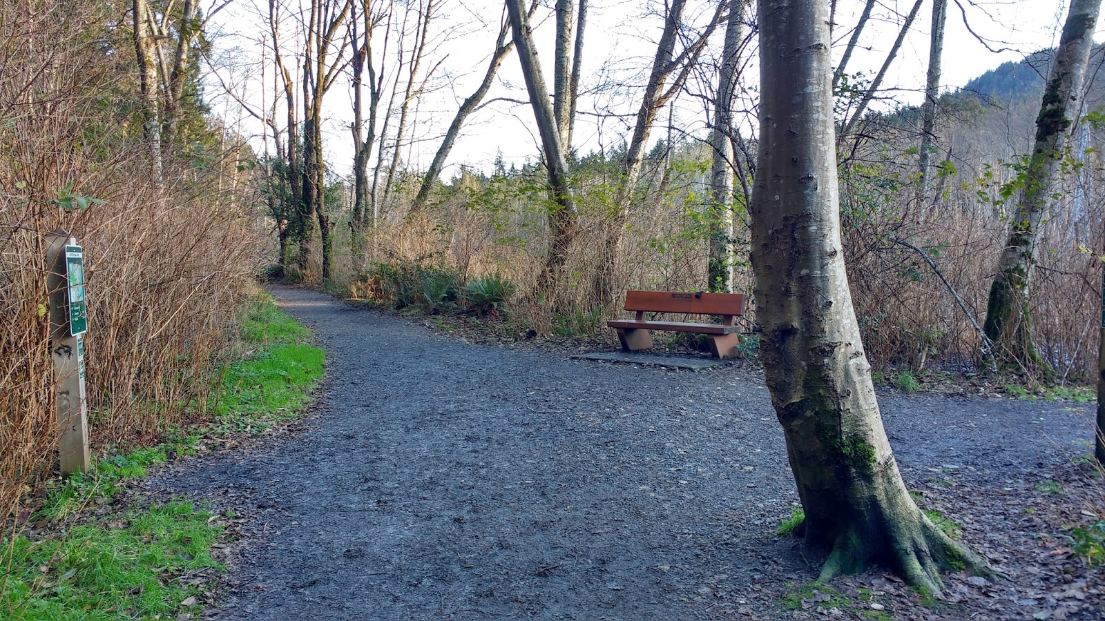
Just past that, I reached a trail junction. On the right was a bench. This is where my planned route would have taken me.


Behold! The "busy roadway"!!

However, I should have re-checked the Bowen trails map, instead of trusting google maps in this case, because the former would have told me that I needed to go left for a tiny bit, to get to a foot trail that went right, and ran parallel to the road. Incorrect assumptions seemed to be a theme for the day. ;) Instead, I walked along Magee Rd.
At the next fork on Magee Rd, the road to the right was clearly marked as private property. the next one too. On that property, the sound of heavy machinery boomed through the forest.


The trail continued to be breathtakingly gorgeous. The sun peeking though the forest strew beautiful patterns off the trees, and buoyed my spirits, after a fairly stressful month of moving.


The trail then headed downward again. At the bottom, another boardwalk. And the first walkers I'd seen since the jogger!


Then, not long after, a spanking new boardwalk!!


Walking over this same portion a few days later, I was shocked to see all of the land underneath that same new boardwalk converted to rushing water!

After a short stint in the forest, this boardwalk led out over a marshy section of the lake. Dead trees stood like ghostly soldiers at attention.


Just after the boardwalk re-entered the trees, was Frog Trail, an unmarked path to Xenia. I recognized it because of its <ahem> "distinctive" tree.


At the next junction, I took the boardwalk. The parks board map confirmed I needed to stay left at the next few junctions.

The path became wide flat and graveled again. This side of the lake was definitely a faster walk than the other side!


HOLY CRAP LOOK WHAT MY NEW PHONE DID WITH THIS, ALL ON ITS OWN!!!!! I am amazed and a little bit scared! :o

(click to enlarge)


The picnic area had several picnic tables under the shade next to the lake, and a couple more in the sun on the roadside. There were trash and recycling barrels, bike racks, a map, and a well-appointed set of porta-potties.

At the other end of the picnic area a bench sat overlooking the boat ramp, and in front of the dam. The trail led past the dam, and back to Magee Rd.


From the road, I got a nice view of the little dam. The air tasted like skating rink. I wondered if it would snow this week. I had seen snow on the nearby mountains this past weekend, and the weather was supposed to drop to an extremely uncommon -5°C in Vancouver this week.


As I reached the junction where I passed the smiling jogger, the sun was slipping behind the mountains, and a Raven flew over my head, exactly as before!


I soon arrived at it, crossed at the crosswalk, and headed back along the path beside Miller Rd. It didn't take long at all to get back to the intersection where I had started.


No comments:
Post a Comment